Earth in Motion : The science behind earthquakes
- rajamohansub
- Aug 6
- 7 min read
On a pleasant spring day in 2022, we (our family) visited the Royal Tyrrell museum of Paleontology ( தொல்லுயிரியல் அருங்காட்சியகம்) at Drumheller, Canada, after an hour and 45 minutes drive from the city of Calgary, Alberta, Canada. In addition to exhibiting one of the world's largest displays of dinosaurs, the museum also showcased the four geological time scales in clear charts and pictorial formats. The charts and the pictures of the geological time scale enthused me to explore further and the net result is this blog .

https://www.youtube.com/watch?v=QHe-mNUw3tE- A full tour of the Royal Tyrrell museum of Paleontology
1.Geological time scales:
In planetary terms, the planet earth has 4.6 billion years of history, whereas human history is incredibly short. Human history is measured in normal time line which are uniform and fixed (eg. centuries, years and months ), whereas, planet earth's history is measured in geologic timelines (eg. Eons, Eras, Periods and Epochs), which are not fixed but variable, divided by physical and biological events .

Our Earth is currently in Phanerozoic Eon (visible life ), starting 541 million years ago, which follows the 4 billion year long Precambrian supereon. Geological time chart showing the various Eras and Periods and their corresponding dates in million years of the current Phanerozoic Eon is given below.

2. Earth and Earth formation:
When the solar system settled into its current layout about 4.5 billion years ago, Earth formed when gravity pulled swirling gases and dust in to become the third planet from the Sun. Like its fellow terrestrial planets, Earth has a central core (inner core and an outer core), a rocky mantle and a solid crust (credit: NASA). Solid crust and the uppermost mantle is called Lithosphere.
The inner core is a solid sphere made of metals iron and nickel and have the temperature as high as 5400 degree celsius. Surrounding the inner core is the outer core made of iron and nickel fluids (Credit : NASA)
.

In between the outer core and the crust is the mantle, the thickest layer. This hot , viscous mixture of molten rock has the consistency of caramel. The outermost layer, Earth's crust is about 30 Km deep on average on land and at the bottom of the ocean it is thinner and extends about 5 Km from the seafloor to the top of the mantle,
Earth's lithosphere which includes the crust and the upper mantle is divided into 7 major plates and several minor & micro plates and are constantly moving roughly at the rate equal to the growth of our fingernails. Asthenosphere is a semi - fluid layer located on the upper part of the Earth's mantle, situated beneath the lithosphere. https://www.britannica.com/science/asthenosphere
3.Tectonic Plates and Earthquakes:
Unlike other planets, Earth's crust is not a single shell. It has got big slabs of crust called Tectonic Plates that float on asthenosphere, a semi-fluid layer and an ocean of slow moving molten rock . Despite its rock solid appearance, our earth surface is constantly drifting and shifting and is driven by the heat from Earth's core.

Earth's outer shell is divided into 7 major tectonic plates ( > 20 million square Kms) . The seven major tectonic plates are : Pacific plate, North American plate, Eurasian plate, African plate, Antarctic plate, Indo- Australian plate and South American plate in the order of area threshold. In addition to that there are many minor & micro plates.
Most seismic activity occurs at three types of tectonic plate boundaries : convergent , divergent and transform . https://www.calacademy.org/explore-science/plate-boundaries-divergent-convergent-and-transform - California Academy of sciences.
The plate boundaries are made up of many faults, and most of the earthquakes around the world occur on these faults. Since edges of the plates are rough , they get struck while the rest of the plates are moving, the energy that would normally cause the blocks to slide past one another is being stored up. When the force of the moving blocks finally overcomes the friction of the jagged edges of the faults and it unsticks, all the stored up energy is released. The energy radiates outward from the fault in all directions in the form of seismic waves ( P waves and S waves) like ripples on a pond. The seismic waves shake the earth as they move through it and when the waves reach the earth's surface, they shake the ground and anything on it ( credit : USGS)

P waves and S waves shake the ground in different ways as they travel through. P waves alternately compress and stretch the crust material parallel to the direction they are propagating. S waves causes the crustal material to move back and forth perpendicular to the direction they are travelling.
The size of an earthquake, called Magnitude, depends on the size of the fault and the amount of slip on the fault and are measured in Richter scale/ Moment Magnitude Scale (magnitude 6 and above are designated as strong/ major earthquakes) using seismographs. Hypocenter is the point where earthquake originates, whereas epicenter is the point on the earth's surface directly above hypocenter.

As of now, Earth scientists are not able to predict earthquakes and many researches are on going.
When i was working in Bombay on 30th September , 1993 , I have experienced the shaking of the furnitures in the room, when an earthquake of magnitude 6.4 struck Latur (about 500 Km from Mumbai) in Maharashtra, India

Most earthquakes and volcanic eruptions do not strike randomly , but occur in specific areas, such as along plate boundaries. One such area is circum - pacific ring of fire, where the pacific plate meets many surrounding tectonic plates. The ring of fire is the most seismically and volcanically active zone in the world. ( credit: USGS).

4.Earthquakes and Tsunami
Not all earthquakes trigger tsunami. When an earthquake is a shallow, high - magnitude underwater event that causes vertical displacement of sea floor, shifting massive volume of water can only trigger tsunami. ( USGS) . Tsunami is a Japanese word meaning ' harbour wave' is used worldwide for waves triggered by the earthquakes and the volcanos eruption, other than astronomical tides. Japan experiences more tsunamis than any other country, with roughly 20% of the world's recorded tsunamis generated off its coast.
A devastating underwater earthquake of magnitude 9.3 with epicentre at Banda Aceh
(Indonesia) struck the island nation on 26th December 2004, 7.58 AM (local time). This earthquake triggered a massive tsunami and devastated most of Banda Aceh ( waves reached 51m high and caused flooding upto 5 Km inland) and also wreaked havoc in 15 surrounding Indian Ocean countries and hit Chennai at 8.50 AM (IST ) travelling a distance of about 1800 -2000KM in about 150 minutes and produced a wave height of 3.2 m at chennai.

The earthquake occured about 30 Kms below the ocean floor along a reverse fault in the Sunda trench where the Indian plate ( part of Indo-Australian plate) subducts beneath the Burma plate ( a micro plate)
Since there were only few tsunamis in the Indian Ocean ( the last major tsunami was in 1883 triggered by volcanic eruption of Krakatoa https://www.youtube.com/watch?v=2LsqbgtgeHY&vl=en - the loudest sound in history Krakatoa 1883), there was little public awareness about tsunami and there was no official tsunami warning system. Many Indians including me, heard the word tsunami on 26th December 2004, for the first time in their life.
https://www.noaa.gov/jetstream/2004tsu_max - 2004 Indian Ocean tsunami
https://www.youtube.com/watch?v=LU7BVDKnbFc - A NOAA scientist's story of survival


5.Pangaea - the most recent super continent
More than 80% of earth's surface - above and below sea level- is of volcanic origin. Gaseous emissions from volcanic vents over hundreds of millions of years formed the Earth's earliest oceans , and atmosphere, which supplied the ingredients vital to evolve and sustain life. Over geologic eons , countless volcanic eruptions have produced mountains, plateaus, and plains , which subsequently eroded and weathered into majestic landscapes and formed fertile soils ( credit : USGS)
By this way, our earth has formed many super continents ( a large land mass that accounts for about 75% of the earth's continental crust) and the present day world is the successor of the most recent super continent called Pangea, which was in existence about 335 million years ago and started to break apart 175 to 200 million years ago . Earlier, there were many super continents and notable of them are : Ur/Vaalbara (formed from 2.7 -3.5 billion years ago), columbia ( existed between 2.1 and 1.8 billion years ago) and Rodina (existed between 1.1 billion to 750 million years ago)
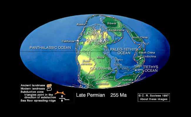
As per the theory of continental drift proposed by the German meteorologist, Alfred Wegener, the super continent, Pangea, break apart by the mantle convection and the tectonic plates ride over lithosphere
https://www.youtube.com/shorts/o6fVgM-JEAc -Theory of continental drift

https://www.scientificamerican.com/article/when-did-plate-tectonics-on-earth-begin-new-research-finds-some-of-the/ - Origin of plate tectonics Scientific American
https://oceanservice.noaa.gov/facts/tectonics.html - What is Tectonic shift - NOAA
As the tectonic plates are ever moving (though slowly) . based on the historic data and measurements taken over a period of time, NASA made a simulation ( PALEOMAP PROJECT) and come out with a likely map of a future world + 250 million years from now.

6. Amazing Earth facts :
The oldest material on Earth, a Zircon mineral, 4.4 billion years old found in the Jack Hills of Western Australia.

Acasta Gneiss is Earth's oldest known rock , formed about 4.03 billion years ago, found in the North West territories of Canada ( located about 300 Km north of Yellowknife, Canada)

Acasta Gneiss rock , the oldest rock on Earth. Credit: Science.ga.ca Earth's magnetic poles reverses about every 300,000 years in an average. and the reversal is very unlikely to happen for at least another 1000 years (Credit: NASA) . https://science.nasa.gov/earth/facts/
The earliest recorded evidence of an earthquake has been traced back to 1831 BC in the Shandong province of China, but there is a fairly complete record starting in 780 BC during the Zhou dynasty in China. ( Credit : USGS)
The largest recorded earthquake in the world was a magnitude 9.5 (Mw) in Chile on May 22 , 1960
The earliest 'Seismoscope ' was invented by the chinese philosopher Chang Heng in AD 132. It only indicated that an earthquake was occuring. The first seismograph was developed in 1890

7.Abbreviation
NASA : National Aeronautics and Space Administration
USGS : United States Geological Survey
NOAA : National Oceanic and Atmospheric Administration
As the above discussion illustrates, we, the humans, even in this era of Artificial Intelligence ( AI) struggling to predict the forces of the nature and when and where the earthquake, volcano eruptions and tsunami strikes. That is the hidden power of nature , we have to appreciate and respect


Lot of information about mother Earth and how this earthquack happens!
Very good article Raj. Laden with lots of links and data this is a very useful treatise on our only Hero the EARTH. Actually to fully read then blog and grasp all data it will take many hours of intense reading.
And whenever we talk about earth …millions and billions of years is very common. My question is how sure we are in pinning these figures. Have heard about carbon dating but is that the only method or there are other methods ?
So the universe was formed 13.8 Billion years due to Big Bang. Solar system was formed 4.6 billion years back. After that the earth formed 4.5 Billion years ago … have these periods been challenged by anyo…
Very informative article. While reading such articles one feels very small in terms of our life span. It will not be an exaggeration to say that understanding nature, origin of universe & its components like galaxies, planets etc is beyond the comprehension of human beings on earth . But humans always tried to understand them which is helpful to some extent to predict and face natural calamities.
Though it is known certain countries are prone to earthquakes, not all countries are fully equipped to handle them when it happens. Japan is an exception where the people from their childhood are trained how to handle them . All their infrastructure like buildings, roads etc are built to withstand earthquakes and so…